


la Roche Byzantine

mousetik
User
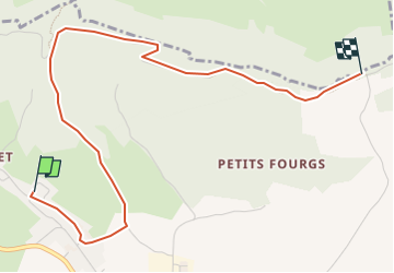

Length
4.2 km

Max alt
1203 m

Uphill gradient
182 m
Km-Effort
6.2 km

Min alt
1041 m

Downhill gradient
46 m
Boucle
No
Creation date :
2022-07-11 14:51:12.072
Updated on :
2022-07-11 14:51:15.106
1h24
Difficulty : Medium

FREE GPS app for hiking
 SityTrail
IGN / Geographical institutes
SityTrail Plus
The world is yours!
About
Trail Walking of 4.2 km to be discovered at Bourgogne-Franche-Comté, Doubs, Les Fourgs. This trail is proposed by mousetik.
Description
au départ du gîte Notre Chalet
Positioning
Country:
France
Region :
Bourgogne-Franche-Comté
Department/Province :
Doubs
Municipality :
Les Fourgs
Location:
Unknown
Start:(Dec)
Start:(UTM)
300598 ; 5191685 (32T) N.
Comments